Official City Release
The Fort Worth Flood of 1949: A city underwater
Mentioned Entities
Source Text
Open source →
A shocking scene unfolds
Picking up the pieces
Lessons learned
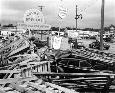
Lloyd Patton Motors, 2733 W. Seventh St. May 18, 1949. The University of Texas at Arlington Libraries, Special Collections.

Floodwaters approach the front of the 7th Street Theatre. Fort Worth History Center Archives.
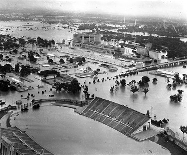
Aerial of 1949 flood, looking north from Farrington Field high school football stadium toward West Lancaster Avenue, West Seventh Street and Montgomery Ward. May 19, 1949. The University of Texas at Arlington Libraries, Special Collections.
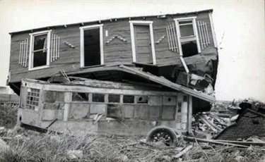
Flood waters deposited a house on top of an old trolley. Fort Worth History Center Archives.

Mother and daughter standing beside flood-destroyed home. The University of Texas at Arlington Libraries, Special Collections.

West Seventh Street under water. The Montgomery Ward building in the upper center received extensive damage. Downtown Fort Worth can be seen in the distance. The University of Texas at Arlington Libraries, Special Collections.

Neighborhood of homes under water. The University of Texas at Arlington Libraries, Special Collections.

Westward aerial view of a flooded Forest Park (bottom half of photo) near the South University Drive crossing of the Clear Fork of the Trinity River. The site of present-day University Park Village, along with Rogers Road and Collinsworth Street, is in the center right. The serpentine river channel in this section of Fort Worth was straightened during the late 1960s. The present-day site of the Log Cabin Village is in the center left. The Texas and Pacific Railyard is in the top right corner. May 17, 1949. Fort Worth History Center Archives.

Packard car dealership at 1204 W. Seventh St. The University of Texas at Arlington Libraries, Special Collections.
Get articles like this in your inbox. Subscribe to City News.
The text and media above are reproduced from the original source for purposes of government transparency and public information under fair use. All content remains the intellectual property of its respective authors and publishers. This reproduction does not imply endorsement by or affiliation with the original publisher. For the authoritative version, please refer to the original source.
Municue is in beta
Tell us what would make press release pages more useful for your workflow.